
Today's walk is part "playing tourist in my home town" and part self-indulgent trip into the past.
Leslieville has been gentrified. So much so that they named it Leslieville. When I was growing up, (as pointed out by my sister-in-law) it was simply The East End.
Back then it housed lower middle class and working class people with the odd well-to-do remnants of founding families thrown in for good measure.
Today it's got an army of well-scrubbed professionals toting about their 1.3 children on bikes that cost more than my first car.
A little bit of everything that ever was still remains...it just costs more. Now we have high-end burger joints, quaint cozy cafe's, art galleries and wall murals.

You know it's going to be a good day when you look into the window of a record store (a RECORD STORE for goodness sake, do people even know what records are anymore?) and see the visage of and artist you've captured in concert over a 150 times.

Here's the legendary Duke Tavern. Cece and I will be back here this evening to see Paul James rock the house. (ed note. He played 3 Dylan songs. The circle is unbroken.)


The Maple Leaf Cottage,
62 Laing St. The Silver Maple tree here was associated with “The Maple Leaf
Forever,” a song written in 1867. The tree fell in a summer storm in 2013. The
song was the unofficial national anthem for several generations of Anglo-Canadians.
One version of the legend has it that Alexander Muir was walking with George
Leslie when a maple leaf floated down and landed on his sleeve – inspiring the
song. There is an historical plaque here.

Moving north along Leslie St we come across this sign of how much the neighbourhood has changed since I last walked these streets.

St.Joseph's Church. I used to go inside these buildings, not so much anymore unless they were built in the 1200's.
St. Joseph’s Roman Catholic Church, 162 Leslie
St. Most labourers here were
Irish Catholics who came to Canada to escape the Irish Potato Famine. They
toiled for low wages in the market gardens and brickyards. To make ends meet,
they also worked cutting ice and fishing. St. Joseph’s, a combined mission
church and school, opened here in 1863. It wasn’t until 1888 that a
separate building for St. Joseph’s Church opened. . There is an
historical plaque here.

I attended St Joseph's School for Grade 1 and 2. The first day of Grade 3 they marched those of us who lived north of Gerrard up Jones Ave to St William's. This school yard always smelled of banana sandwiches. That's my memory.

A little further north we find the patrons of Leslieville Public School inviting you back next weekend.

I'd say Leslieville Fun is more than Fair.
Leslieville
Public School, 254 Leslie St. The log cabin school that stood here opened in 1864.
The first principal was Alexander Muir who composed “The Maple Leaf Forever”,
but who was also well-loved as an innovative teacher who taught with love and
did not strap or beat children. A new brick school was erected in
Leslieville in 1874.
And now we light upon the incredibly changed facade of Riverdale Collegiate.

They won some kind of school board lottery and expanded their footprint to double it's original size. A massive pool and no more lawn greens facing Gerrard for the student to lounge on.
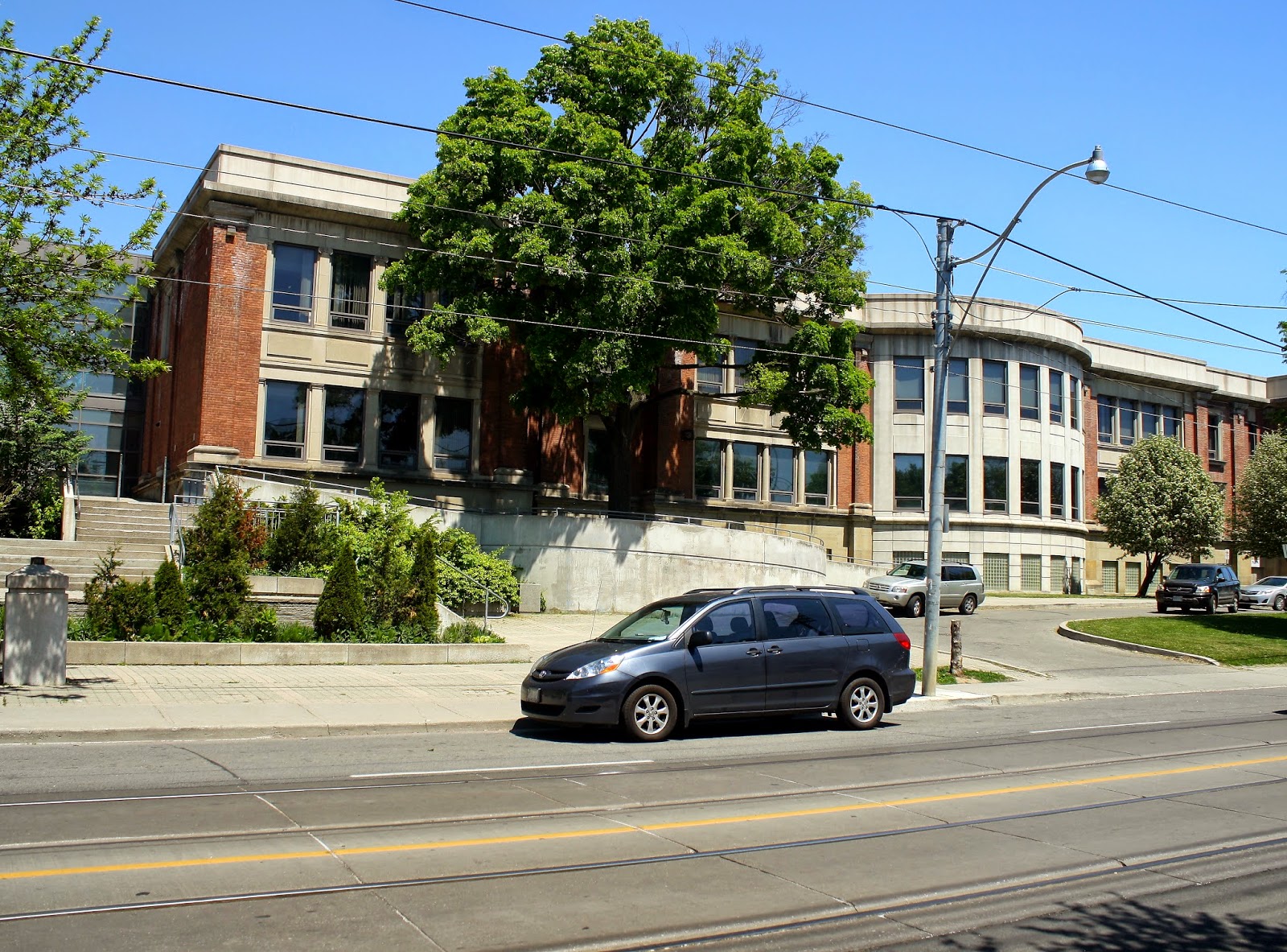
Win some, lose some.
It was open and I gravitated to that place I found myself so often.

Hello Mr Romney, I was sent here because....
And what's a high school visit without a row of lockers.

Here's a view of the north west corner of Gerrard and Jones.

Starbucks eh?
Now on to the corner of Gerrard and Marjory where, at 1020 Gerrard stood Paul's Barbershop and my boyhood home. The property to the right was Harry's Hardware and the Sushi place was Collegiate Lunch, or Marco's. Cece and I met at Marco's a month before our last year in high school.

(This part is for members of my family that might see this.)
For the record I don't like what they've done with the back of my boyhood home. It used to have a back yard and a fence. Now it looks like parts of rural Mississippi I've visited.


Going east on Gerrard we pass the school again and head north on Leslie to Harriet Hill.

And how did we get to Monarch Park to watch our football team. Through the underpass at the top of Woodfield Rd.

Pedestrian
Underpass (Woodfield Rd & railway) From 1907 neighbours called for an underpass
under the railway. Children were endangered crossing the tracks to go to
school. Pedestrian traffic grew with the creation of Monarch Park across the
tracks. The Roden Ratepayer’s Association demanded action. In 1924 this tunnel
was built in the ravine of Ashbridge’s Creek’s west branch. The City put the
Creek underground in a large sewer pipe.
Here's the other side of the underpass.

And looking into Monarch Park.

The next stop is outside Roden School, originally built in 1907, now a cement and glass monstrosity that was the '60's architecture. They do have this funky mural of a neighbourhood map.

151
Hiawatha Roden School In 1909 the City of Toronto annexed
Midway, the area south of the Danforth between Greenwood Ave & the Beach.
In the boom that followed developers rapidly subdivided the area. It became a
working class suburb, a Little Britain. The City built schools: the Roden
School (1907), Duke of Connaught School (1909), Bruce Junior School (1923),
& Riverdale Collegiate (1907). The Roden School was originally the Ashdale
School. It was renamed after long-time school trustee & shoemaker Ephraim
Roden.
Turning up Greenwood we come across another artifact of an early founding family

Wagstaff
Brickworks(Wagstaff Rd) Albert Wagstaff was a city alderman and important brick manufacturer.
Around 1910 his brickyard here made about 3 million bricks a year. In 1912 one
of his Martin brick machines could turn out 85,000 brick a day. Wagstaff built
the Vera Apts, named after his only daughter. The corners are decorated with
over-baked, vitrified brick or “clinkers”. The building faces his brick plant
on Wagstaff Ave., the only brick plant remaining in Leslieville. The
Wagstaff home itself is buried behind factory additions, but can be seen from
the Vera’s front steps. On his death he left his clay pit to his gambling &
drinking buddy, Albert Harper, who turned it into Toronto’s biggest garbage
dump. In 1956 it became the Greenwood Subway Yard.

Now we are in the area of one of the most peculiar streets in Toronto, Craven Rd. Notice the fencing along the west side of the street as we're looking north.

Not to mention that ominous note from JP Sartre.
Here's the same street looking south, more fences. Why you may ask?

Craven
Road From
1900-1914 British immigrants poured in, drawn by cheap housing & jobs.
A “Shacktown” grew here just outside City limits where taxes were low; services
non-existent, regulations few. Edmund Henry Duggan bought land next door to the
Ashbridge estate. He was involved with the Toronto House Building
Association which made a profit selling land to low-income families. Duggan’s
holdings were laid out in very small lots on a narrow lane called Erie Terrace.
There were no sewers; no garbage collection; no police or fire protection. The
east side was packed with tiny houses. The west side wasn’t developed until
after 1909 when it became part of the City of Toronto.Erie Terrace’s shacks were owner-built
& lacked plumbing & toilets. A 1907 advertisement captures the essence
of the street: $10 A FOOT—Erie Terrace, 100 feet north of
Gerrard street cars, no money down, lumber supplied to build. David, 75
Adelaide east.Ashdale Ave was developed for more affluent homeowners
who wanted nothing to do with Erie Terrace and cut a deal with the City. The
City took part of their backyards to widen Erie Terrace (renamed Craven Rd)
& Ashdale homeowners got a fence along the west side of Craven Rd to keep
their poorer neighbours out.
South along Coxwell we come across the remains of the Shamrock Tavern, now a fitness club and bowling alley.

Like we said at the beginning, nothing is forever.
As we near the end of our walk we still come across a few landmarks.
The Toronto Gospel Lighthouse at 17 Rhodes Ave

This is the lot for the Lost Church, 1402 Queen St
E. The remnants of a Wesleyan Methodist Chapel,
built in 1859, are hidden here behind a 1920’s factory facade. The
church measured 40×30 feet and seated 250. From about 1830 until the building
of the chapel, the local Methodists held services in each others’ homes,
especially the Ashbridge home.


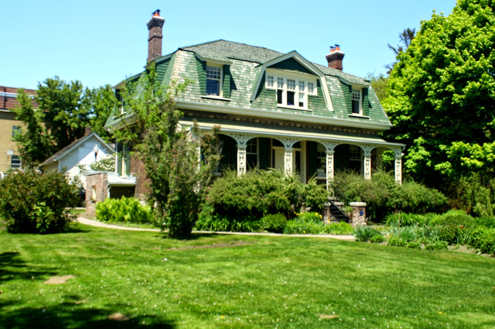
Ashbridge
House, 1444 Queen St. E. Archaeologists dug here and found artifacts and
ash pits dating to the Woodland period of First Nations history. The first
Europeans to live here were Pennsylvania Quaker Sarah Ashbridge and her
family. They arrived in Upper Canada in 1793 and built log cabins here a
year later. They farmed the land for over a century . In 1854 Jesse
Ashbridge built this house, designed by Joseph Sheard. The house was renovated
and modernized by his widow Elizabeth in 1899. The foundation of the
original log cabin became a rose garden. The ravine of Ashbridge’s Creek is
still visible in the garden. There is an historical plaque here.

The home could use a little work on the roof but it is a stately manor.
Thomas Beatty, 6 – 8
Cherry Nook Gardens This was originally the farm
of Mary Ashbridge and her husband, Parker Mill. After they died, the
property passed to Capt. Brent Neville, except for a small area near Queen
St. Thomas Beatty bought it
and built the house of bricks he made himself. This house
originally stood at the north end of a farm lane running south down the
“Kingston trail”. Beatty, a Loyalist descendant from New Brunswick,
arrived in Toronto in 1840. He was the Ashbridge’s farm manager until 1850 when
he became a hotelkeeper. In 1859 he donated the land for the Methodist
Chapel. In 1865 he married Ella Winnett and in 1868 he “retired” and
became a jack-of-all-trades. Sadly, in 1877 two of the Beatty children
died in this house during a diphtheria epidemic that killed many children
here.


Just to even out the memory making.
Next up The Danforth and where Cece grew up.